

The Transect
“Urban-to-Rural Transect: a system that identifies the varieties
of human and natural habitats by intensity and mix, both for
analysis and to project future urbanism through codes.”

Before the Transect became a tool for urban design, zoning reform, and neighborhood planning, it was first a way of understanding nature.
A transect is a cross-section through an environment. In ecology, it is used to study how one habitat transitions into another. A walk from the ocean to the forest, for example, may pass through open water, beach, dune, scrub, grove, and woodland. Each zone has its own character. Each supports different forms of life. Each has different conditions of soil, water, exposure, vegetation, movement, and shelter.
The important lesson is not simply that these habitats are different. The deeper lesson is that each habitat has an internal logic. A dune should not behave like a forest. A marsh should not be treated like a meadow. A woodland edge is different from a deep forest. Nature is not organized by arbitrary lines on a map. It is organized by relationships, gradients, thresholds, and patterns of fitness.
The New Urbanist Transect applies this same ecological logic to human settlement.
Just as natural habitats range from wilderness to cultivated land, human habitats range from rural countryside to urban core. Between those extremes are many distinct conditions: hamlets, villages, neighborhoods, main streets, town centers, and downtowns. Each has its own proper form. Each has a different relationship between buildings, streets, landscape, public space, commerce, mobility, and civic life.
The Transect is a way of restoring order to that relationship.
It recognizes that the built environment is not simply a collection of buildings. It is a habitat for human life.
The Problem of the Flattened Landscape
For much of human history, settlements developed with a recognizable range of places. There were farms and countryside. There were small villages and towns. There were neighborhood streets, civic squares, market streets, and urban centers. Each place had a role. Each had a scale. Each had a proper degree of intensity.
The postwar development pattern disrupted this order.
Rather than allowing rural places to remain rural and urban places to become truly urban, modern zoning and development practice often produced a flattened middle condition. It spread a low-intensity suburban pattern across landscapes that once contained a richer range of human and natural habitats. Housing was separated from commerce. Streets were widened for traffic movement rather than shaped for civic life. Daily needs were pushed farther from homes. Buildings were set back behind parking. The public realm became residual space. The car became the organizing device.
The result was not merely suburbia. It was the overextension of one settlement pattern into places where it did not belong.
This is why so many modern landscapes feel neither rural nor urban. They are too developed to function as countryside, but not connected enough to function as towns. They consume land like rural development, depend on infrastructure like urban development, and often fail to deliver the social, economic, and civic benefits of either.
The Transect offers a corrective.
It does not argue that every place should become urban. Nor does it romanticize rural life as the only authentic condition. Instead, it insists that different places should be allowed to be different, and that each should be designed, coded, and built according to its own proper nature.
““The transect conceives of rural and urban conditions as interconnected parts of a system that requires different responses, depending on where development is situated. It then strengthens the connection by basing urban planning and design on the degree of relative intensity of urban elements with respect to natural systems.””
Transect Context Zones
T1: Natural
The Natural Zone includes all lands that have been permanently protected from development. This includes national parks, state parks and most land trust lands. Here, in the wilderness, nature trumps mankind every time. This is actually a place that is just a bit dangerous to humans; something could bite you, for example. The only buildings you’re likely to find here are forest rangers’ cottages or campground structures. This is the quietest place you can find (except in a thunderstorm or a buffalo stampede), and it’s the place where the stars shine the brightest.
T2: Rural

The Rural Zone includes lands that are not currently slated for development, but that have not been permanently protected from development. Most of the Rural Zone in the eastern United States is farmland and countryside. This zone isn’t quite as dangerous, as long as you stay out of the fence where the big bull lives. Man begins to shape this zone, but he uses natural or rustic materials to do it, like the rows upon rows of corn in the field converging on the horizon, the columns of fruit trees marching like soldiers over the hills of the orchard, or the lonely lines of barbed wire strung along cedar posts at the edge of a field. You may hear a distant tractor plowing the fields by day, or the cows mooing as they come home in the evening. The blips of the fireflies over the fresh-mown fields are still the most numerous lights, but you may occasionally see a light in the window of a farmhouse as you go by, at least until bedtime.
T3: Sub-urban Neighborhood

The Sub-urban Neighborhood Zone isn’t exactly the ‘burbs. It’s close, to be sure, but it doesn’t include some things like the big box retail that you might instead find in a highway business district. The Sub-urban Zone is most similar to the areas at the outskirts of town where the town grid begins to give way to nature. Here, lots are usually larger, streets begin to curve with the contour of the land, and fences, if you have them, look more like their country cousins around the homestead. Streetlights and sidewalks begin to occur in this Zone, but only on the busiest streets. Natural features such as streams still trump things built by humans, in part because things are far enough apart in the Sub-urban Zone that you simply cannot afford the cost of modifying nature.
T4: General Urban

The General Urban Zone is the place that settlements finally start coalescing into strongly identifiable neighborhoods, each with their own center that you can walk to in five minutes or less. You have clearly made it into the town or city by the time you get to this Zone. This is the place where the houses pull up close enough to the street that you can sit on your porch and talk to your neighbor who has stopped to lean over your fence with the latest news. And this is the place that kids across America are rediscovering after having been held hostage at the end of a cul-de-sac for the past half-century by anyone with a drivers’ license. Here, the neighborhood is compact enough that they can safely walk or ride their bikes down tree-lined sidewalks to the ice cream store down on the corner and return home before they finish the cone.
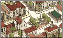
T5: Urban Center

The Urban Center Zone is Main Street America. Main Street was never far from the life of every American town. There were sometimes townhouses at the edge of Main Street and there was always a good selection of apartments over the Street itself, and over the square. Young couples just getting started would often live in an apartment over Main Street, but they weren’t alone. The Main Street neighborhood was as diverse as any, including merchants living over their shops and old folks who didn’t want to have to saddle up to get to all the necessities. You could see lights on in the windows over the square every evening and could hear mothers calling their kids to come in and do their homework long after the old men out in front of the general store had folded up their checkerboard and gone home for the day.
T6: Urban Core

The Urban Core Zone only occurs in cities. It is the brightest, noisiest, most exciting part of the city. It is every city’s answer to Manhattan or Michigan Avenue, with the city’s tallest buildings, busiest streets, and most variety. It’s the place where you should find one-of-a-kind functions like City Hall, but it’s also the place with all the galleries and the biggest selection of restaurants. The Urban Core is the place where mankind trumps nature; it’s where the only trees are lined up in planters beside the street, and where the river running through town is contained in grand stone embankments. That may sound dismal to nature-lovers, but the Urban Core is so intriguing that thousands or even millions stay there for months on end, leaving nature in the wilderness to grow in peace. The Urban Core is mankind’s greatest gift to nature.
““The purpose of community is to create built environments that become ever-closer to functioning as the human equivalent of nature’s interactive, mutually supportive and self-renewing systems.”
”
Natural Habitat and Human Habitat
The genius of the Transect is that it links human settlement back to ecological thinking.
A natural habitat is shaped by climate, terrain, vegetation, water, soil, and exposure. A human habitat is shaped by streets, blocks, lots, buildings, frontages, civic spaces, daily needs, transportation, and social customs. Both require internal coherence. Both suffer when their underlying logic is ignored.
A wetland cannot be treated as if it were dry upland without consequence. A main street cannot be designed like a highway commercial strip and still function as a main street. A rural road cannot be widened, signalized, and lined with parking lots without ceasing to feel rural. A neighborhood cannot support ordinary social life if every daily need requires a car trip.
The Transect helps us see these mismatches.
It asks whether the elements of a place belong together. Are the streets consistent with the buildings? Are the buildings consistent with the public realm? Are the uses consistent with the intended level of activity? Is the landscape appropriate to the zone? Is the code producing the kind of place people actually expect to experience?
When the answer is yes, a place feels coherent. When the answer is no, the place feels confused.
Much of the built environment today feels confused because its elements come from different habitats. We place urban-scale traffic on neighborhood streets. We place suburban parking requirements on main streets. We require rural setbacks in urban centers. We insert commercial buildings into neighborhoods without shaping them as civic or walkable places. We preserve natural fragments without connecting them into meaningful ecological systems.
The Transect allows us to recover the proper relationship among these elements.
Why Zoning Matters
Zoning is not just a legal tool. It is a form of civic instruction.
Every zoning code tells land what it is allowed to become. It determines whether buildings will meet the street or retreat from it. It determines whether homes and shops may coexist. It determines whether a neighborhood can grow incrementally or must remain frozen in a single pattern. It determines whether daily needs can be near housing or must be separated by distance. It determines whether a place will become walkable, drivable, mixed, segregated, adaptable, or brittle.
In that sense, zoning functions like DNA. It carries instructions that reproduce physical outcomes over time.
A conventional zoning code often organizes land by separated use: residential here, commercial there, office elsewhere, civic uses by exception, industrial uses in another district, and parking distributed everywhere. This system may be administratively simple, but it is often physically destructive. It separates the ingredients of daily life and then requires expensive infrastructure to reconnect them.
A Transect-based code begins from a different premise. It does not ask only, “What use is allowed here?” It asks, “What kind of place is this supposed to become?”
That question changes everything.
In a rural zone, the code should protect rural character, agricultural viability, ecological systems, and low-intensity settlement patterns. In a general urban neighborhood, the code should support walkable blocks, human-scaled streets, diverse housing types, and neighborhood services. In an urban center, the code should allow mixed use, attached buildings, active frontages, reduced setbacks, shared parking, civic spaces, and a higher level of activity.
The rules should change because the habitat changes.
The Failure of One-Size-Fits-All Development
One of the great mistakes of modern development is the tendency to apply the same standards everywhere.
The same parking ratios. The same road sections. The same setbacks. The same separation of uses. The same stormwater assumptions. The same lotting logic. The same product types. The same engineering templates. The same landscape buffers. The same traffic expectations.
This uniformity may appear efficient, but it often produces places that are poorly adapted to their context.
A rural edge should not be governed by the same standards as a town center. A main street should not be forced to meet the same parking expectations as a suburban shopping center. A neighborhood street should not be designed as if its primary purpose were regional traffic movement. A downtown building should not be required to behave like an isolated object in a parking field.
When codes ignore context, they erase place.
The Transect restores contextual intelligence. It allows development standards to be calibrated according to the intended character of each place. It gives communities a way to distinguish between preservation, growth, repair, intensification, and transformation.
Not every place should change in the same way. Some places should be protected. Some should be gently completed. Some should be repaired. Some should absorb significant growth. Some should become centers of civic and economic life.
The Transect helps identify which is which.
The Role of the Center
A complete human habitat requires centers.
The traditional main street was not an accident. It was the place where daily needs, civic identity, commerce, and social life overlapped. It contained the hardware store, the pharmacy, the bank, the post office, the grocery, the barber, the café, the church, the town hall, the upstairs apartment, the professional office, the public square, and the informal sidewalk conversation.
It was not merely a shopping district. It was the common room of the community.
Modern development often replaced this pattern with isolated commercial pods. Instead of a main street, we built shopping centers. Instead of mixed-use buildings, we built single-use boxes. Instead of civic space, we built parking fields. Instead of walkable proximity, we built access management. Instead of a center, we built destinations.
A destination is not the same thing as a center.
A destination may attract trips. A center organizes life.
The Transect reminds us that every complete neighborhood, town, or city needs an intelligible center. That center may be modest. It may be a corner store, a small square, a school, a civic building, a chapel, a café, or a cluster of neighborhood-serving businesses. But without some form of center, residential development becomes socially and economically incomplete.
Housing alone does not make a neighborhood. A subdivision can contain hundreds or thousands of homes and still lack the structure of a complete place.
The center is where daily life becomes visible.
Housing and the Transect
Housing types also belong to the Transect.
Large-lot homes, farmhouses, cottages, townhouses, duplexes, courtyard buildings, mansion apartments, live-work units, main street apartments, and downtown residential buildings each have a natural place within the rural-to-urban order. The issue is not whether one housing type is better than another. The issue is whether each housing type is located and designed in a context where it can contribute to a coherent human habitat.
A detached house on a quiet street can be a beautiful and appropriate form of housing. But when that becomes the only widely available housing model, the community loses adaptability. Young adults, single-person households, young families, empty nesters, service workers, teachers, aging parents, and people seeking smaller or more connected living arrangements may all find themselves poorly served.
A complete community needs a range of housing types because human life contains a range of household types and life stages.
The Transect allows that range to occur without chaos. It provides a spatial order for housing diversity. More rural and suburban zones may contain larger lots and detached houses. General urban neighborhoods may include cottages, duplexes, fourplexes, townhouses, accessory units, and small apartment buildings. Urban centers may include apartments above shops, live-work units, courtyard buildings, and mixed-use residential buildings. Urban cores may include larger multifamily buildings and more intense forms of residential life.
This is not density for its own sake. It is housing fitted to place.
Mobility and the Transect
Transportation also changes across the Transect.
In rural areas, longer-distance travel by car is often necessary and expected. In suburban areas, cars remain important, but streets should still be safe, legible, and humane. In general urban neighborhoods, walking and biking should become practical for short trips. In urban centers, walking should become the primary way people experience the place once they arrive. In urban cores, transit, walking, biking, and shared mobility become increasingly important.
The mistake is not that cars exist. The mistake is designing every habitat as if the car should dominate every movement.
A healthy Transect gives people transportation choices appropriate to their context. It does not demand that a rural resident live like a downtown resident. It also does not force an urban resident to behave as if they live in the countryside. Each place should support the movements that fit its form.
This means street design must be calibrated.
A rural road, neighborhood street, main street, avenue, boulevard, alley, lane, and civic square are not interchangeable. Each has a different purpose. Each shapes behavior. Each produces a different public realm.
When transportation engineering ignores the Transect, it often overbuilds streets in low-speed environments and undercuts the very places communities are trying to create. A main street designed like a highway will not function as a main street. A neighborhood street designed primarily for throughput will not support neighborhood life. A rural road widened beyond its context will invite development pressure and erode rural character.
Mobility must serve place, not replace it.
The Ecological Value of Urbanism
The Transect also clarifies a point that is often misunderstood: urbanism and environmental care are not opposites.
A compact, walkable, mixed-use center can be one of the most effective tools for protecting nature. When human activity is concentrated in the right places, more land can remain rural, agricultural, or natural. When daily needs are closer together, fewer trips require long-distance driving. When buildings share walls, streets, utilities, parking, and infrastructure, land and resources can be used more efficiently.
The environmental problem is not intensity itself. The problem is misplaced intensity, scattered development, and land consumption without civic or ecological return.
A well-formed urban center can reduce pressure on the countryside. A complete neighborhood can reduce the need for excessive vehicle travel. A connected block structure can make walking practical. A compact development pattern can make infrastructure more productive. A calibrated Transect can protect sensitive land by directing growth where it belongs.
This is why the rural and urban ends of the Transect depend on each other.
The countryside is better protected when towns and cities are allowed to be complete. Urban centers are healthier when natural systems are respected and integrated. A region that suppresses urbanism often does not preserve nature; it merely spreads development across more land.
The proper balance is not anti-growth or pro-growth. It is place-based growth.
The Transect as a Tool for Repair
Many communities are not starting from a blank slate. They are working with inherited patterns: conventional subdivisions, strip corridors, disconnected pods, oversized arterials, underperforming commercial centers, isolated apartment complexes, and fragmented open space.
The Transect is useful because it can diagnose these conditions.
A strip corridor may be trying to function as T5 commerce while being physically designed as automobile-oriented sprawl. A subdivision may be located near enough to support a neighborhood center but lack the street connections and zoning permissions to make one possible. A downtown may have T5 or T6 potential but be constrained by suburban parking requirements and outdated use restrictions. A rural edge may be under pressure from scattered large-lot development when the better answer would be to preserve open land while directing growth into a compact village or neighborhood.
The Transect helps ask the right questions.
What is this place today? What does it want to become? What Transect condition is appropriate here? What physical elements are missing? What rules are preventing the intended form? What should be protected? What should be intensified? What should be connected? What should be repaired?
This makes the Transect not only a planning theory, but a practical method for community repair.
The Transect and Incremental Growth
The best places rarely emerge all at once. They grow, adapt, thicken, and mature over time.
The Transect allows communities to understand that maturation. A settlement may begin with a rural crossroads, grow into a hamlet, become a village, and eventually develop a stronger town center. A neighborhood may begin with houses and a small civic space, then add a corner store, then live-work buildings, then a more complete main street. A commercial strip may be retrofitted over time into an urban center as buildings move toward the street, parking is reorganized, blocks are created, and housing is introduced.
This incremental process matters because many communities cannot afford instant urbanism. They need a framework that allows them to begin modestly and grow intelligently.
The Transect gives that growth a direction.
It helps ensure that early decisions do not prevent later maturity. Street networks, block sizes, lot patterns, civic sites, utility placement, and code standards should be established so that a place can evolve. A neighborhood that begins simply should not be trapped forever in its first phase. A town center should be allowed to become more complete as demand grows. A rural edge should not be prematurely fragmented in ways that make future conservation or village formation impossible.
Good planning does not merely regulate what is built today. It protects the possibility of what a place may need to become tomorrow.
Coding for Place, Not Abstraction
A Transect-based code is most powerful when it is locally calibrated.
The purpose is not to impose a generic urban model everywhere. The purpose is to study the best existing patterns of a region and translate them into usable rules. What are the traditional lot widths? How do buildings meet the street? What frontage types belong here? What tree species shape the public realm? How are porches, stoops, shopfronts, galleries, arcades, fences, walls, and yards used? What street sections feel right? What block sizes support walking? What building types have historically served different households and businesses?
This is where zoning becomes an act of civic memory.
A good code does not merely permit development. It carries forward the patterns that allow a place to remain itself while adapting to new needs. It gives property owners, developers, designers, public officials, and residents a shared language for what belongs.
That shared language is essential. Without it, every project becomes a negotiation from scratch. Every approval becomes a battle over preference. Every development proposal is judged by fear, speculation, or political pressure. A Transect-based code gives the community a more stable foundation. It says, in effect: this is the kind of place we are trying to create here, and these are the rules that will help produce it.
The Human Purpose of the Transect
The Transect is often discussed in technical terms: zoning districts, frontage types, building placement, street sections, density, intensity, mixed use, and block structure. Those details matter. But they matter because they shape human life.
The purpose of the Transect is not to make better diagrams. It is to make better habitats.
A child should be able to walk safely to a park or a friend’s house. A teenager should have some measure of independence before owning a car. A parent should be able to combine daily errands without spending the day in traffic. An older adult should be able to remain connected to community even after driving becomes difficult. A small business should be able to find a foothold. A neighbor should be able to recognize familiar faces. A civic building should have a place of honor. A natural corridor should be protected as more than leftover land.
These outcomes do not happen automatically. They are produced by the physical and regulatory structure of place.
The Transect gives us a way to align that structure with the realities of human life.
Recovering the Full Range of Place
The ultimate value of the Transect is that it recovers the full range of place.
It allows nature to be nature. It allows rural land to remain rural. It allows neighborhoods to be walkable and humane. It allows main streets to become centers of daily life. It allows downtowns to carry intensity. It allows different households, businesses, landscapes, and public spaces to find their proper setting.
This is a more generous vision than the one offered by conventional zoning. It does not force a false choice between growth and preservation, urbanism and nature, houses and commerce, cars and walking, privacy and community. Instead, it organizes those relationships.
A region does not need every place to be the same. It needs every place to understand its role.
The Transect helps a community ask: What should be protected? What should be cultivated? What should be connected? What should be intensified? What should be repaired? What should be allowed to mature?
Those questions are the beginning of better zoning, better planning, better development, and better stewardship.
Conclusion: A Habitat Worth Inheriting
The built environment is never neutral. It teaches patterns of life. It determines what is near and what is distant, what is possible and what is inconvenient, what is shared and what is isolated. It shapes how we move, how we gather, how we age, how we raise children, how we encounter neighbors, how we support local enterprise, and how we relate to the natural world.
The Transect gives us a disciplined way to think about those relationships.
It reminds us that human settlement is part of a larger ecology. It teaches that every place has a proper character. It shows that zoning should not merely separate uses, but should cultivate coherent habitats. It restores the idea that a community is not a collection of disconnected parts, but a living pattern of nature, buildings, streets, public spaces, commerce, and civic life.
When properly understood, the Transect is not simply a planning tool.
It is a way of recovering the relationship between land and life.